| |||
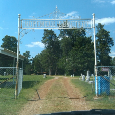
LOCATION: Hopewell Cemetery is located in the northwest quadrant of the county, It is in Block 31 of the Lamar County Road Map produced by American Drafting and Services revised December 1993. DIRECTIONS: The cemetery is about 4 miles northeast of the intersection of Loop 286 and Highway 79 on Farm Market Road 2820, .2 miles from the intersection of Highway 79 and FM 2820, in the community of the same name. GPS COORDINATES: 33° 42' 21.9636" N, 95° 37' 50.934 W.
(33.706101 Latitude and -95.6308150 Longitude)OLDEST KNOWN BURIAL: The oldest inscribed grave is that of Chestina Jackson Burton who died 14 Aug 1860 NUMBER OF GRAVES: There are 1,398 known graves in the cemetery. (July 2017) SIGNS/MARKERS: There is a state highway marker for the cemetery. LAST ENUMERATION: Barbara Harris of the Hopewell Cemetery Association provided a list of the graves that was double checked against a recording of the cemetery completed in February 1992 by Patricia Ferguson, Ruth Renfro and Roberta Woods. Mary Hall Ferguson updated the cemetery photographs in June 2017. ADD'L INFORMATION: None. PICTURE(S):
View pictures of the headstones.
Search for names in this and other cemeteries.
Return to the map page.
Return to the list of cemeteries.
Return to the main Lamar County, TX page.
Special thanks to Jeff Kemp for designing the Lamar County banner. |
|
|
Copyright © 1996 —
— The Lamar County TX Website Team This website adheres to the NGS "Standards for Sharing Information with Others" regarding copyright, attribution, privacy, and the sharing of sensitive information. |