| |||
LOCATION: Harmon Cemetery is located in the southwest quadrant of the county off Farm Market Road 824, near the Harmon Community. It is in Block 52 of the Lamar County Road Map produced by American Drafting and Services revised December 1993. DIRECTIONS: From Highway 82 W, about 12 miles west of Paris, turn south onto FM 137. Follow FM 137 about 11.5 miles to FM 824 (right past Hickory Grove Cemetery. Turn south (right) onto FM 824 and continue 2.5 miles to County Road 27450 . Turn right onto CR 27450 and cemetery is about one mile down on the north side of the road, behind the old Harmon school. In 2011, the school is no longer visible for all the trees and undergrowth. GPS COORDINATES: 33° 34' 18.42" N, -95° 43' 38.78" W
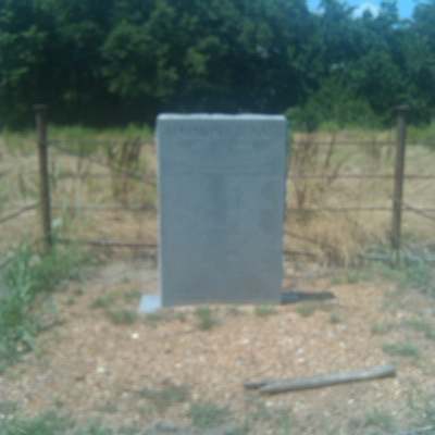
(33.571783 Latitude and -95.727439 Longitude)OLDEST KNOWN BURIAL: The oldest inscribed grave is that of Albert Kinkead, who died 5 Jul 1878. NUMBER OF GRAVES: There were only 19 graves found in 1992, but there was evidence that there may be many more. (July 2017) SIGNS/MARKERS: There is a large granite marker in front of the school listing the names of people who built the community of Harmon, 1857-1982. LAST ENUMERATION: The cemetery was recorded by Butch and Betsy Mills on March 13, 1992. ADD'L INFORMATION: The cemetery is fenced with barbed wire and can not be seen from the road. It is about 100 foot by 300 foot and the graves are very scattered and broken. PICTURE(S):
Search for names in this and other cemeteries.
Return to the map page.
Return to the list of cemeteries.
Return to the main Lamar County, TX page.
Special thanks to Jeff Kemp for designing the Lamar County banner. |
|
|
Copyright © 1996 —
— The Lamar County TX Website Team This website adheres to the NGS "Standards for Sharing Information with Others" regarding copyright, attribution, privacy, and the sharing of sensitive information. |