| |||
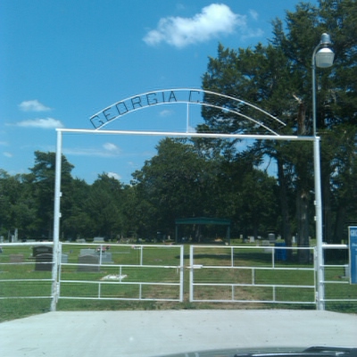
LOCATION: Georgia Cemetery is on Farm Market Road 2352 in the northwest quadrant of the county. It is in Block 20 of the Lamar County Road Map produced by American Drafting and Services revised December 1993. DIRECTIONS: about 19 miles northwest of Paris City limits following the route of Highway #79 to Farm Market Road 2820 to Highway #38 to Farm Market Road 2352, northwest of the Tigertown community. GPS COORDINATES: 33° 45' 25.76 N, 95° 49' 47.96 W.
(33.75716 Latitude and -95.82999 Longitude)OLDEST KNOWN BURIAL: The oldest inscribed grave is that of S. C. Cummins who died 21 May 1863. NUMBER OF GRAVES: There are 478 known graves in the cemetery. (July 2017) SIGNS/MARKERS: There is a state highway marker for the cemetery. LAST ENUMERATION: The cemetery was recorded in October 1991 by Ron Brothers, Debbie Burks, Patricia Furgeson, Ruth Renfro and Roberta Woods. ADD'L INFORMATION: None PICTURE(S):
View pictures of the headstones.
Search for names in this and other cemeteries.
Return to the map page.
Return to the list of cemeteries.
Return to the main Lamar County, TX page.
Special thanks to Jeff Kemp for designing the Lamar County banner. |
|
|
Copyright © 1996 —
— The Lamar County TX Website Team This website adheres to the NGS "Standards for Sharing Information with Others" regarding copyright, attribution, privacy, and the sharing of sensitive information. |