| |||
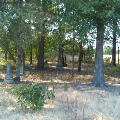
LOCATION: Biardstown Cemetery is a Black cemetery located in the southeast quadrant of the county in the Biardstown community. It is also called the Skidmore Cemetery. It is in Block 57 of the Lamar County Road Map produced by American Drafting and Services revised December 1993. DIRECTIONS: The cemetery is 9.8 miles from the intersection of Loop 286 and Farm Market Road 1497. Take Farm Market Road 1497 to Biardstown, turn east on Farm Market Road 3426. Go about 1/4 of a mile. Part of the cemetery is in the stand of trees. GPS COORDINATES: 33° 32' 05.63 N, 95° 29' 58.70 W.
(33.5342743 Latitude and -95.4988437 Longitude)OLDEST KNOWN BURIAL: The oldest inscribed grave is that of Miner Price who died 3 Feb 1887. NUMBER OF GRAVES: There are 175 known graves in the cemetery. (July 2017) SIGNS/MARKERS: There is no sign. LAST ENUMERATION: The cemetery was recorded by Ron Brothers in April 1993. ADD'L INFORMATION: In April 1993, the cemetery was not well kept and many graves were unmarked. In 1998 the Black community began to call it the Skidmore Cemetery, named after the Skidmore family which owned the land surrounding it at the time. It appears that Mr. Skidmore keeps the area clean and was rewarded by having the cemetery named after him. PICTURE(S): This cemetery photo is used with permission from Betsy Mills.
View pictures of the headstones.
Search for names in this and other cemeteries.
Return to the map page.
Return to the list of cemeteries.
Return to the main Lamar County, TX page.
Special thanks to Jeff Kemp for designing the Lamar County banner. |
|
|
Copyright © 1996 —
— The Lamar County TX Website Team This website adheres to the NGS "Standards for Sharing Information with Others" regarding copyright, attribution, privacy, and the sharing of sensitive information. |